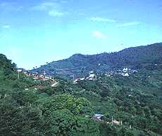
| Chiang Rai province
covers some 11,700 square kilometers with a
population of 1.4 million. The average
elevation is 580 meters above sea level, Myanmar borders on the north, and
Laos on the north and northeast. The provincial capital is 829 kilometers
north of Bangkok . Chiang Rai was
founded in 1262 by King Meng Rai and was the first capital of Lanna Thai
(Kingdom of a Million Rice fields). The province contains Thailand's
northernmost point at Mae Sai which is well known for its crisp mountain
scenery, and hilltribes. North Chiang Rai and falls within the region known
as the Golden Triangle, the area where the borders of Thailand, Myanmar and
Laos converge.
How To Get There:
By Bus:
The 11-hour journey from Bangkok can be made by air
conditioned coaches and non-air conditioned buses originating from the
Northern Bus Terminal on Bangkok's Kamphaeng Phet 2 (Tel: 936-3660 (or)
9378065 for further details).
By Air:
Thai Airways Internationals (Tel : Bangkok / Lan Luang 280-0100-110, Silom
234-3100-19, Asia Hotel 215-2020) Angle Airlines (Tel : Bangkok 953-1304)
operates daily flights from Bangkok and other northern Thai cities.
City Attractions:
King Meng Rai the Great Monument
This is located on the city outskirts, be-side the northern road to Mae
Chan, and honors the monarch who founded Chiang Rai in 1262.
Ku Phra Chao Meng Rai
Situated in Wat Ngam Muang, on Ngam Muang Hillock,this stupa contains King
Meng Rai's ashes and relics.
Wat Phra Sing
This temple, on Singhakhlai Road, is a fine example of Lanna Thai religious
architec-ture. The Phra Buddha Sihing image now housed in Chiang Mai's Wat
Phra Sing was formerly enshrined here.
Wat Phra Kaeo
Located behind Wat Phra Singh, this tem-ple is said to have been the
original place where the Emerald Buddha, now enshrined in Bangkok's Wat Phra
Kaeo (Chapel of the Emerald Buddha) was enshrined. Wat Phra That Doi Chom
Thong This ancient hilltop pagoda overlooks the Mae Kok River and predates
the founding of Chiang Rai as the capital of Lanna Thai.
Hat Chiang Rai
Located 5 kilometres from the city, this scenic riverside area and promenade
is a recreation area for local inhabitants.
Mae Kok River
Known in Thai as Maenam Kok, this scenic 130-kilometre long waterway runs
through the heart of Chiang Rai. The river is a major transportation artery
from neighboring Chiang Mai province, especially the town of Tha Thon (180
kilo-meters north of Chiang Mai provincial capital), from whence long-tailed
boats make the 3-4 hour journey every day at 12.30 PM (Chiang Rai-Tha Thon:
10.30 AM). The river passes several hilltribe settlements and elephant camps
from where jungle treks originate.
Khun Kon Waterfall Forest Park
Located 30 kilometres south of Chiang Rai provincial capital, along Routes
121 & 1208, the 70-metre high Khun Kon Waterfall is the highest in the
province.
Attractions and Roundtrips:
Please see our asiatours.net Tours: Click here |
Out-of-City Attractions
Amphoe Mae Cham - Hot Spa
Located 8 kilometers from Mae Chan, along the Mae Chan-Mai Ai Road, this
complex has hot mineral water and bath-house facilities. Accommodation is
also available.
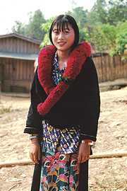
Hilltribe Development & Welfare Centre
15 kilometers along the route to Doi Mae Salong, the centre aids and
administers local hilltribe settlements. Hilltribe handicrafts, including
woven cloth and silverware, are on sale.
Doi
Saen Chai
5 kilometers beyond the Welfare centre, this Akha hilltribe village can be
reached solely by 4-wheel drive vehicles.
Doi
Tung
This northernmost Thai mountain con-tains several scenic spots, including
the Doi Tung Royal Villa, the Mae Fah Luang Botanical Garden, the
mountaintop Wat Phrathat Doi Tung which affords a spectacular view of the
surrounding area, and contains Buddha relics, and various hilltribe villages
in natural settings.
Pamee Akha Village
This picturesque village is one of the most accessible Akha settlements in
Chiang Rai province, and is located on the way to the summit of Doi Tung.
Doi Mae Salong
Located some 40 kilometers beyond Mae Chan, a mountaintop settlement known
as Santi Khiri is home to descendants of Chinese Nationalist soldiers who
fled to, and settled in Thailand, in 1940. Mountainside plantations of
coffee, and fruit orchards, provide scenic variety. The area is particularly
picturesque in December and January when Thai cherry trees are in blossom.
Accommodation, restaurants and opportunities for horse-riding and elephant
trekking number among major attractions.
Mae Sai
This border town faces Myanmar across the Mae Sai River, and is located 62
kilometers north of Chiang Rai on Highway No. 110. Numerous shopping
opportunities exist for popular Thai and Burmese goods.
Khun Nam Nang Non
(Lagoon of the Sleeping Lady) Located 12 kilometres before reaching Mae Sai
Community Centre along a 2-kilometre spur road, natural rock formations
resemble a reclining female to give the tree-shaded area its name.
Tham Pum-Tham Pla (Reed & Fish Caverns)
Located 1 kilometer north of the 'Sleeping Lady Lagoon', and 1.8 kilometers
from High-way No. 110, these caves are known for their spectacular
interiors.
Tham Phayanak
Located within a few hundred meters from the Reed & Fish Caverns, this cave
is regarded as being especially beautiful thanks to its multi-colored rocks.
Tham Pha Chom Located 2.5 kilometers west of Mae Sai, this cave is noted for
its beautiful stalactites, and as a place of meditation.
Chiang Saen
This riverside town facing the Mekong River is 30 kilometers from Mae Chan
via Highway No. 1016, predates Chiang Rai and is famous for a special style
of Bud-dha image.
Chiang Saen National Museum
This petite museum exhibits local objects, including Chiang Saen-style
Buddha images and Lanna Thai artifacts.
Wat Phra That Chedi Luang
This ancient 88-metre high brick pagoda, next to the museum, is the tallest
religious monument in Chiang Rai.
Wat Pa Sak
Located outside the city walls, some 200 metres from the Tourist Service
Centre, this deserted temple, with ornamental stucco motifs, is regarded as
being one of the most beautiful examples of Lanna architecture in northern
Thailand.
Wat Phra That Chom Kitti
This hilltop temple has a pagoda containing a Buddha relic.
Wat Phra That Pha-Ngao
Located 4 kilometres along the Chiang Saen-Chiang Khong road, this temple's
hilltop pagoda offers a spectacular view of the Mekong River and Laos.
Chiang Saen Lake
South of Chiang Saen, along Highway No. 1016 (a 2-kilometre trip from the
Km. 27 marker), this one square kilometer lake hosts migratory waterfowl
during the winter months. Birds are seen at their best and most plentiful
from November through February. Accommodation and water-sports facilities
are available.
The Golden Triangle
8 kilometers north of Chiang Saen, this riverside area marks the spot where
the borders of Thailand, Myanmar and Laos con-verge.
Wat Phra That Doi Pu Khao
This riverside temple near the Sop Ruak Market, offers a spectacular view of
the Golden Triangle's riverine and mountain areas.
Mekong River Trips
Boats can be hired from Chiang Saen to travel upstream to the Golden
Triangle, and downstream to Chiang Khong. The trip to the Golden Triangle
takes some 30 minutes, the trip to Chiang Khong about 1 hour and 30 minutes
depending on river cur-rents and water levels.
|
